Cliffs of Moher
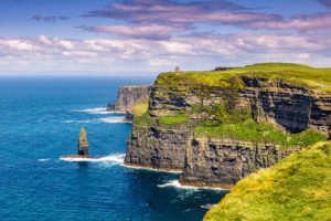
The Cliffs of Moher are sea cliffs located at the southwestern edge of the Burren region in County Clare, Ireland. They run for about 14 kilometres. At their southern end, they rise 120 metres (390 ft) above the Atlantic Ocean at Hag’s Head, and, eight kilometres to the north, reach their maximum height of 214 metres (702 ft) just north of O’Brien’s Tower, a round stone tower near the midpoint of the cliffs, built in 1835 by Sir Cornelius O’Brien, then continue at lower heights. The closest settlements are Liscannor (6 km south) and Doolin (7 km north).
 From the cliffs, and from atop the tower, visitors can see the Aran Islands in Galway Bay, the Maumturks and Twelve Pins mountain ranges to the north in County Galway, and Loop Head to the south. The cliffs rank amongst the most visited tourist sites in Ireland, with around 1.5 million visits per annum.
A 19th-century Photochrom postcard of the cliffs, with Leacmayornagneeve rock in the foreground
The cliffs take their name from an old promontory fort called Mothar or Moher, which once stood on Hag’s Head, the southernmost point of the cliffed coast, now the site of Moher Tower. The writer Thomas Johnson Westropp referred to it in 1905 as Moher Uí Ruis or Moher Uí Ruidhin. The fort still stood in 1780 and is mentioned in an account from John Lloyd’s A Short Tour Of Clare (1780). It was demolished in 1808 to provide material for a lookout/telegraph tower that was intended to provide warning in case of a French invasion during the Napoleonic wars.
Tourism
The cliffs are one of the most popular tourist destinations in Ireland and topped a list of attractions in 2006 by drawing almost one million visitors (at the official visitor centre, with additional visitors accessing other locales); the total visit number is now around 1.5 million per annum. Since 2011, they have formed a part of the Burren and Cliffs of Moher Geopark, one of a family of geotourism destinations throughout Europe that are members of the European Geoparks Network and also recognized by UNESCO. The cliffs are also a “signature point” on the official Wild Atlantic Way tourist trail.
While the cliffs can be accessed at multiple points, and there is an 18 kilometre Cliff Walk, the majority of visitors come to the official visitor centre.
Visitor centre
In the 1990s the local authority, Clare County Council, initiated development plans to enable visitors to experience the cliffs without significant intrusive man-made amenities. In keeping with this approach, a modern visitor centre, the Cliffs of Moher Visitor Experience, was built into a hillside approaching the cliffs. The centre was planned to be environmentally sensitive in its use of renewable energy systems including geothermal heating and cooling, solar panels, and grey water recycling.
The €32 million facility was planned and built over a 17-year period and officially opened in February 2007. Exhibits include interactive media displays covering the geology, history, flora and fauna of the cliffs. A large multimedia screen displays a bird’s-eye view from the cliffs, as well as video from the underwater caves below the cliffs. There are also two cafés and several shops. Accessibility is a priority, and wheelchairs are available to borrow.
Cliffs of Moher Cruise
As of 2018, the centre charges €6 per adult, with children under 16 admitted free. This covers parking, access to the visitor centre and Atlantic Edge exhibition, and a contribution towards conservation and safety at the cliffs.
Visitor numbers
The visitor experience recorded 1.427 million visits in 2016, up 14% on 2015, and up 52% in off-peak December, for example. Numbers are so large, and have grown so fast, that there are capacity problems at time, notably from 11 a.m. to 4 p.m. daily in peak season, and visitors are increasingly encouraged to come at other times, with discounts given to coach operators who book for off-peak slots, and late opening of the centre introduced for July and much of August. Furthermore, later-arriving visitors have been facilitated by the fitting of automatically opening exit gates from the official car parking facilities.
Recognition
The Cliffs of Moher Visitor Experience won an award in the Interpret Britain & Ireland Awards 2007 awarded by the Association of Heritage Interpretation (AHI). Although the award was specifically for the Atlantic Edge exhibition, the AHI assessed the entire visitor centre and site. The citation stated that the entire visitor centre was “one of the best facilities that the judges had ever seen.”
Viewing
The official Cliffs of Moher Coastal Walk runs for 18 km, from Hag’s Head to Doolin, passing the Visitor Centre and O’Brien’s Tower, with good viewing throughout, subject to rain or sea fog.
There are two paths near the visitor centre, the official one being set back a little for safety, while an unofficial path runs closer to the edge. In July 2016 the so-called Cliff Walk, outside the official Cliffs of Moher amenities, was temporarily closed because of the risk of rock falls. People were warned to stay on the official path further of the cliff edge instead of the unofficial seaside trail.
Separate ferry trips also allow tourists to view the cliffs from sea level, and at certain times fixed-wing aircraft from Connemara Airport also provide a viewing opportunity.
Geology and wildlife
The cliffs consist mainly of beds of Namurian shale and sandstone, with the oldest rocks being found at the bottom of the cliffs. It is possible to see 300-million-year-old river channels cutting through, forming unconformities at the base of the cliffs.
At peak season, there are an estimated 30,000 pairs of birds living on the cliffs, representing more than 20 species. These include Atlantic puffins, which live in large colonies at isolated parts of the cliffs and on the small Goat Island, and razorbills. The site is an Important Bird Area.
A wide range of sea life can also be seen, from grey seals through porpoises, dolphins, minke whales and basking sharks, as well as, occasionally, sunfish. On land, feral goats, foxes, badgers and the Irish hare are found, along with various breeds of farm cattle.
Popular culture
The Cliffs of Moher have appeared in numerous media. In cinema, the cliffs have appeared in several films, including The Princess Bride (1987) (as the filming location for “The Cliffs of Insanity”), Harry Potter and the Half-Blood Prince (2009), and Leap Year (2010). The cliffs are mentioned in the Martin Scorsese film Bringing Out the Dead (1999) and are noted in the 2008 documentary Waveriders as the location of a large surfing wave known as “Aileens”.
In music, the cliffs have been the scene for music videos, including Maroon 5’s “Runaway!”, Westlife’s “My Love”, and Rich Mullins’ “The Color Green”. Most of singer Dusty Springfield’s ashes were scattered at the cliffs by her brother, Tom.
Transport
Bus Éireann route 350 links the Cliffs of Moher to several locations: Ennis, Ennistymon, Doolin, Lisdoonvarna, Kinvara and Galway. This service includes a number of journeys each way daily. There is also a privately operated shuttle bus that serves the site from Doolin.


This article uses material from the Wikipedia article “Cliffs of Moher”, which is released under the Creative Commons Attribution-Share-Alike License 3.0.