Ballyshannon, County Donegal
Ballyshannon is a town in County Donegal, Ireland. Located at the southern end of the county where the N3 from Dublin ends and the N15 crosses the River Erne, it claims to be the oldest town in Ireland.
Ballyshannon, which means “The Mouth of Seannach’s Ford”, after a fifth-century warrior, Seannach, who was slain there, lies at the mouth of the river Erne. Just west of the town, the Erne widens and its waters meander over a long sandy estuary. The northern bank of the river rises steeply away from the riverbank, while the southern bank is flat with a small cliff that runs parallel to the river. From its idyllic setting, the town looks out over the estuary and has panoramic views of mountains, lakes and forests.
History
Archaeological sites dating as far back as the Neolithic period (4000 BC – 2500 BC) have been excavated in Ballyshannon and surrounding areas, representing settlement and ritual activity from early periods of human settlement. Finds have ranged from fulachta fiadh (burnt mounds) dating from the Bronze Age (2500–500 BC), to a possible brushwood trackway thought to date to an earlier Neolithic period, to the recent discovery of a previously unknown medieval church and cemetery containing hundreds of skeletons thought to date from between 1100 and 1400. This site yielded numerous artefacts including silver long cross pennies and halfpennies dating from the reign of Henry III (1251–1276) and Edward I (c.1280–1302). Other finds included bone beads, shroud pins, and pieces of quartz which were found placed in the hands of many of the skeletons.
 Numerous other sites from various periods are thought to exist, including a neolithic tomb, and the grave of Aed Ruad, High King of Ireland, upon which St. Anne’s church (Church of Ireland) was supposedly built, occupying the highest of the town’s vantage points—Mullgoose. Nothing remains to mark either tomb, the last vestige of the mound on Mullaghnashee having been obliterated in 1798 when a fort was constructed on the hill-top. The 18th-century churchyard and the paupers’ burial ground were both referred to as Sidh Aedh Ruaidh, the Fairy Mound of Red Hugh. The ‘sheeman’ (Anglicisation of the Irish sidh) in Mullgoose means ‘fairies’. Popular belief assigned the interior of hills to fairies’ dwelling places and local tradition has handed down accounts of the exploits of the fairy folk, especially among the Finner sand-hills and in the Wardtown district of Ballyshannon.
The Vikings, according to the Annals of Ulster, attacked nearby Inishmurray Island in 795. Later they used the River Erne to attack inland, burning Devenish Island Monastery in 822. The Annals also record that in 836, all the churches of Loch Erne, together with Cluain Eois (Clones) and Daimhinis (Devenish Island) were destroyed by the “gentiles”. In 923 and 916 respectively, “a fleet of foreigners on Loch Erne plundered the islands of the lake”, as well as the surrounding territories.
It was in Ballyshannon, around 1793, that Viscount Castlereagh, the future Chief Secretary for Ireland and, later, British Foreign Secretary, had his famous vision of the radiant boy. Known at the time as The Hon. Robert Stewart (he became Lord Castlereagh in 1796), he was serving as a young Army officer and M.P. for Down in the Irish Parliament at the time. Lodging in the old Military Barracks in the town, Stewart (as he then was) retired for the night. Looking into the fire he saw the form of a boy emerge from the flames, grow larger and larger and vanish. The radiant boy is a well-known figure in English and Irish folklore, and is often supposed to foretell death. William Allingham later wrote a poem about the incident.
The Enniskillen and Bundoran Railway (E&BR) opened in 1868 and had a station at Ballyshannon. The Great Northern Railway (GNR) operated the E&BR line from 1876 and absorbed the company in 1896. The partition of Ireland in 1922 turned the boundary with County Fermanagh into an international frontier. Henceforth Ballyshannon’s only railway link with the rest of the Irish Free State was via Northern Ireland, and as such was subject to delays for customs inspections. The Government of Northern Ireland closed much of the GNR network on its side of the border in 1957, including the E&BR as far as the border. This gave the Republic no practical alternative but to allow the closure of the line through Ballyshannon between the border and Bundoran. Thereafter the nearest railheads for Ballyshannon were Sligo in the Republic and Omagh in Northern Ireland, until in 1965 the Ulster Transport Authority closed the line through Omagh as well.
A hydroelectric power station was built in the town in the 1950s. The project, or ‘Scheme’ as it was then referred to, brought engineers, electricians, and specialists in hydroelectricity from many parts of the country and abroad to the town, which experienced a boom during the decade-long construction period. The scheme involved building a dam upriver from the town and digging out a deep channel or tailrace to lower the riverbed through the town to increase the head of water at the dam to drive the turbines. The new plant was named Cathaleen’s Fall hydroelectric power station. Before the station was built, the river was wide, and the water level much higher than it is today. A long bridge spanned from the northern shore to the ‘port’ on the southern bank. The waters spilled over a number of waterfalls, among them Assaroe Falls, before meandering out to sea. Today, however, the river runs through a narrow channel, far below the level of either bank and a narrower single arch bridge has replaced the old one. The newly built Ballyshannon – Bundoran bypass has added a new, more modern bridge over the river. A pedestrian bridge was also constructed to mark the millennium.
During the Second World War the British and Irish governments quietly reached an agreement to create an air corridor between nearby Belleek and Ballyshannon, the “Donegal Corridor”, which was used by British Royal Air Force flights from Northern Ireland into the Atlantic Ocean. This was used by the aircraft which located the German battleship Bismarck.
Local attractions
- The Rory Gallagher International Tribute Festival takes place in Ballyshannon on June Bank Holiday weekend.
- Ballyshannon Folk Festival takes place every year on the August bank holiday weekend. This Festival is now the longest running Folk and Traditional Festival in the world. It has just returned to its roots in The Marquee for its 40th Birthday.
- Ballyshannon & District Museum. Located on the second Floor of Slevins Dept Store in the heart of Ballyshannon. The Museum is opened each day Monday To Saturday from 10am to 5.30pm. Ample free Bus and Car parking in the Market Yard. Coffee Shop. The Museum opened in April 2013 and has had 30000 visitors to date. The Museum includes exhibitions on Rock Guitarist Rory Gallagher, the story of the Kildoney Fishermen, the Battle of Ballyshannon (1598), The Mysterious Leprechaun and Devil Stones, The Famine, the Workhouse, The building of the Power Station, the fishing industries, Town Life through the ages, Famous Ballyshannions, Sporting Success, Ancient International Connections to Ballyshannon, World War 1 & 2, The Donegal Corridor, The Donegal Railway.
- Caoimhin Drummond’s downtown jump shot.
Transport and Communications
Bus Éireann offers routes to cities and major towns in Ireland including Cavan , Dublin , Sligo and Galway. Ulsterbus offers services to cities and major towns in Northern Ireland including Belfast and Derry. Feda ODonnell offers routes to and from Gweedore to the west of Ireland, including Sligo and Galway, via Ballyshannon.
The nearest railway to Ballyshannon is Sligo station which is served by trains to Dublin Connolly and is operated by Iarnród Éireann.
Commercial broadband is available in Ballyshannon, installed by Donegal County Council and provided by all major broadband providers.
People
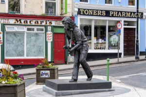
- Guitarist and singer Rory Gallagher was born in Ballyshannon and the town centre contains a statue erected in his memory. The Gallagher clan, originated in the barony of Tirhugh to the north of Ballyshannon. The Rory Gallagher statue is sometimes dressed in a Donegal jersey.
- William Allingham, poet
- William Conolly, politician
- Brendan “PlayerUnknown” Greene, game designer (PlayerUnknown’s Battlegrounds)
- Charlie McGettigan, singer and Eurovision Song Contest winner
- Gelasius Ó Cuileanáin (probably)
- Gary Walsh (Gaelic footballer)
- Brian Murray (Gaelic footballer)
- James Myles, politician is buried in the town
- Robert Johnston VC, international (Ireland & Lions) rugby player
International relations
See also List of twin towns and sister cities in Ireland
Twin towns – Sister cities
Ballyshannon is twinned with:
- Grenay, France Flag of France.svg
- Séné, France Flag of France.svg
Sport
- Local Gaelic Athletic Association club is Aodh Ruadh who won the Division 2 League in 2017.
- The local rugby club is Ballyshannon R.F.C.
- The local soccer club is Erne Wanderers.
- The local Basketball club is the Eightyeighters
Schools
- Creevy National School, Creevy, Ballyshannon.
- Kilbarron (St. Anne’s) National School.
- Rockfield National School, Knocknashangan, Ballyshannon
- The Holy Family National School (formerly known as St. Joseph’s Primary School).
- St. Catherine’s Primary School (known in Irish as Scoil Naomh Chaitríona).
- Gaelscoil Eirne, an Irish-medium national school
- Coláiste Cholmcille Secondary School.
